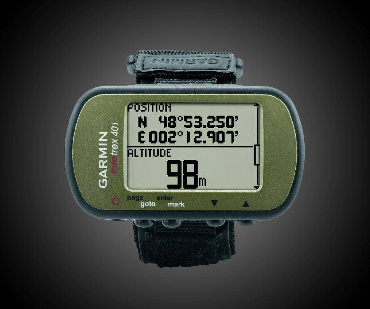
Garmin Foretrex Hiking GPS | ||||||||||||
| ||||||||||||
Product Description
The Foretrex 401 is a slim wrist-mounted GPS navigator perfect for outdoor activities that require the use of both hands. Foretrex 401 combines a high-sensitivity waterproof GPS receiver, electronic compass and barometric altimeter into a lightweight device ideal for hikers, skiers and campers. To share data easily, you can connect Foretrex to your computer with USB or just send data wirelessly to another device.
Retrace Your Steps
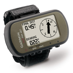
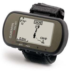
No matter where your adventure takes you, you'll never worry about getting lost with the Foretrex 401. Foretrex keeps track of your path and displays it as a dotted trail on the screen. Just turn on Foretrex's TracBack feature, and you can retrace your path back to where you started. Keep track of your bearing and altitude with Foretrex 401's electronic compass and barometric altimeter. You can save locations in memory as waypoints, so you always can find your way back to any important place, like your campsite or vehicle. And with up to 17 hours of battery life and replaceable AAA batteries, you'll never worry about making it back.
Track Your Data
Foretrex 401 lets you create and store routes to all of your favorite places and provides other helpful information, including a trip computer, sunrise/sunset times and hunting and fishing information. For even more data, connect Foretrex 401 to a wireless accessory, such as a heart rate monitor, cadence sensor, or clip it on your bike with the accessory bike mount. To keep track of your trip, connect your Foretrex to your PC or Mac with USB to store your waypoints, routes and tracks on your computer. You also can share waypoints, routes and tracks wirelessly with another Foretrex 401.
Get Connected
You've been busy exploring and now you want to store and analyze your activities. With a simple connection to your computer and the Internet, you can get a detailed analysis of your activities and send tracks to your outdoor device using Garmin Connect. This one-stop site offers an activity table and allows you to view your activities on a map using Google Earth. Explore other routes uploaded from more than 12 million customers and share your experiences on Twitter and Facebook. Getting started is easy, so get out there, explore, and share.
What's in the Box
- Foretrex 401
- Wrist expansion strap
- USB cable
- Manuals
Features
- Features high-sensitivity GPS receiver with HotFix for improved performance and reception in heavy tree cover or deep canyons
- Keeps track of routes, tracks and waypoints, and heart rate with add on heart rate monitor (sold separate). Uses standard AAA batteries. 2 required.
- TracBack feature retraces user's path on the easy-to-read LCD display;Display resolution 100 x 64 pixels;Battery life Up to 17 hours in GPS mode;Track Log 10000. Display size : 1.42 x 0.91 inches
- Supports dual position readout so user can view current location in multiple formats. Audible tones. Hold the compass level when navigating to ensure maximum accuracy
- Features trip computer, sunrise/sunset times, hunting/fishing information, electronic compass and barometric altimeter

Top Reviews
Garmin could just as easily put a 64 MB or 128 MB memory chipby Stephenax (5 out of 5 stars)
March 10, 2018
With the default Garmin directories deleted (you should do this when you get your 401), the device shows 4.2 MB total, with 645 KB used by the system, leaving 3.5 MB available for routes, waypoints, and tracks. Garmin could just as easily put a 64 MB or 128 MB memory chip. This tiny memory might be due to an old processing chip with a puny limitation of memory addressing.
I wouldn't go to the field without it.
by Dan (5 out of 5 stars)
January 19, 2019
I got this to go through a training course that involved patrolling through the woods and trying to find bad guys. Before we were allowed to start using GPS, it was difficult to accurately navigate wooded, hilly terrain using a compass and pace counts. We would often approach our objective from the wrong direction or have to search for it. Once we were allowed to start using a GPS, I brought this. No guess work at all. I had it hanging from my flack or on my wrist in the hot, cold, wet, dry, everything. This is great!
Ease of use: It's a small computer on your wrist, it'll take a evening of tinkering to get used to all of its features. Once you take the time to understand it, it is so easy to use in the field. Push a button and find your current azimuth, push a button and see how far you are from your next point, push a button and get an instant 10 DIGIT GRID!
Battery life: It'll last you a full day of continuous use. I left this thing on and hanging from my flack when we were driving vehicles through trails in the mountains all day for 10 days. I was the navigator and this is the only reason we made it back every night! I'm stubborn and don't always read instructions and toward the end of those 10 days I realized there is a place to plug in a charger rather than replace batteries all the time. It's safe to say its covered well and inconspicuous.
Durability: When I hang this from the front of my flack and run, it bounces against the flack constantly. It doesn't break, it doesn't malfunction, it just does its job. Whether it's in the 30's and raining/snowing, or really hot outside and dry, this thing does its job. I recommend buying a screen protector to prevent scuffs. That's what I did and mine is still looking great. I have no fear of simply throwing this thing in my pack and heading out. I'm not concerned it's going to break in my pack or anything weird like that.
Versatility: I've used this on the east coast and it was great. I got to Japan, changed the grid zones, and it was still great. I guess that what "Global" means. . . Need to find a place out in the woods? Punch in a grid and it'll take you there. It'll give you an arrow to follow, you follow it, you find the place you're looking for. Need to let someone know where you are? One of the screens give you a constant 10 digit grid. Need to follow a route? Take the time to insert points using grids, then select which points you want to visit and in which order. Then just follow the arrow. You can even label the points with words and icons. What elevation are you at? Yeah, it's on the screen all the time if you want it to be.
I'm done typing. . . just buy this thing already!
So Nice
by Mendi (5 out of 5 stars)
November 29, 2018
This straps on the outside, so there is no fumbling around trying to find it, or accidentally losing it. It's like a speedometer, just glance down and there's the information. Has a battery indicator, which is handy. The data port cover fell off, so the data port will eventually plug up to the point that it won't work, so I need to do something about that. The screen shifts around, trying to second-guess which direction you're going, which is helpful except when you're on a fidgety horse who is backing up and spinning and stuff, with the GPS constantly "thinking" and making one adjustment, then another, so the direction is not reliable in that situation. No internal map, which is fine, those maps are not detailed enough anyway from what I have seen. So I need this GPS. It is very good, a life-saver, makes a big difference especially when trying to find something and also in the cold, dark, and foggy. Can set waypoints easily. I carry extra batteries so can run the unit until the batteries in place are completely used up.
the manual is terrible! This my third Garmin product
by Paul Zike (3 out of 5 stars)
December 29, 2017
The Garmin Foretrex 401 is OK, the manual is terrible! This my third Garmin product. Two for my car, the 401 is my first for hiking. The instructions do not explain how to enter a destination when hiking. There is a place with blank areas to enter something, but as much as I keep looking there is nothing in manual to give you details. The product looks ok, I just not sure who wrote the manual. It appears dummies like me must have a magic box to reach in and get answers. If I call, maybe I will get an answer, but on the trail, forget it! Worst generic manual I have ever seen! I was tempted to give less stars.
Solid piece of equipment
by Ryan Jarvis (4 out of 5 stars)
June 25, 2018
Very solid product. The more I use it the more I like it. The wireless sync feature is handy if you have multiple people trying to get the same waypoints. Extremely accurate as far as location goes, the only issue I've had with it is that when I plot a waypoint, it sometimes tells me to go in the opposite direction. I have better luck at the "Drawing" screen. All in all though, a solid, handy little piece of equipment. I and several others just used these during a field excercise, and they held up extremely well. This is such a great piece of equipment that myself and several other squad leaders bought our own when supply said they couldn't get them.
Great product.
by NS (5 out of 5 stars)
November 23, 2016
Great product. I'm a Marine grunt and use this in the field for getting MGRS grid and elevation. Pretty much all officers and NCO's/SNCO's in the infantry use this b/c it's so small, accurate, and convenient on your wrist or plate carrier. Lat/Long is default, but you can go into settings and change. Antenna is so sensitive that I've received satellite link inside a building, cloudy days, thick forest, and inside an up armor HMMWV. I have not tried using it in a very built up urban environment like a large US metropolitan city (I imagine you'll have problems getting link), but small towns or villages, and you're good.
Five Stars
by Bryan Russo (5 out of 5 stars)
April 19, 2017
Awesome, I couldn't be happier with my foretrex plus the shipping was really fast. thank you so much
Used in Combat with excellent results
by Crimson (5 out of 5 stars)
December 18, 2010
I am currently deployed in Afghanistan and have used this GPS during my combat patrols for about two weeks now. I have found that it performs perfectly. It is easily configured for MGRS, the metric system, and the compass can be set for Mils which makes calling for polar fire missions very easy. I love the fact that I have a 10-digit grid on my wrist. It cuts down on weight, not having to lug a DAGR around, and as I am taking notes during Community Engagements I can grab the grid right off my wrist as I write. So far it has stood up to the insane temperature differences from day to night. It has stood up to the dust (which gets into EVERYTHING - and has ruined two of my digital cameras [including a so-called dust-proof one]) with flying colors. The batteries last about 8 hours and it takes AAAs which are easy to carry. You can easily beam waypoints from one GPS to another. Several guys in my platoon carry the same one which makes it very easy. I am looking forward to using this when I get home to track my runs. So far I have found nothing wrong with this to speak of. I would definitely recommend it for whatever purpose you would use it for. I haven't tested its water-proofness yet; however, it stands up to my sweat very well.
Doesn't work in single-digit temperatures
by kb (2 out of 5 stars)
November 24, 2018
I went for a hike in the San Juans, Colorado, in November. Temperatures for the hike ranged from 6F to -8F; the Garmin worked well initially (probably due to the temperature inside my vehicle). I kept the Garmin inside my coat, next to my chest/underlayer, but unfortunately it didn't keep accurate elevation, direction, nor GPS coordinates. I checked such with my other analogue devices, and was surprised at how off the readings were! I'm guessing it was due to the extreme temperatures, probably okay for moderate/mild hiking conditions, wouldn't recommend for use on hikes of higher elevation (around 14,000ft) and in single digit temperatures. Lithium batteries were nearly dead after a 12 hour hike. Not a bad idea to keep old-school devices on-hand just in case....
Needs a better manual, other than that, NICE
by Pat-inCO (4 out of 5 stars)
October 12, 2015
NEEDS A MANUAL! I want (wanted) the display shown on the Amazon Web page and there is . . nothing . . in either the quick start guide or the Owner's Manual to tell you how to get it. I'm still a little vague on how I found it, BUT, I did. Now, when I shut it off, that display has become one of the "options". Thus it is easy to get back to. The manual problem is why I rated it a four rather than a five.
It DOES lock up with the satellites very quickly. I remember one of my old units that took several minutes to lock up. NOT this one. Very quick.
Other than finding the display I wanted, the set up time is minimal.
Seems to be working very well.
Physical size is larger than I had anticipated, but if you envision two AAA batteries on your wrist, plus a little bit of plastic to hold them, you have a good estimate of its size.
Customers Who Bought This Item Also Bought
- [3-Pcs] for Garmin Foretrex 401/301 GPS Screen Protector,Full Coverage HD Clear Anti-Bubble and Anti-Scratch Foretrex 301
- IPG Compatible with Anti - Glare Garmin Foretrex 401 Hiking GPS (2X) (1 Clear & 1 Anti-Glare Protector) Invisible Film Screen Protector Guard Cover Free Bubble -Free
- Suunto M-9 Wrist Compass
- (2-Pack) EZGuardZ Screen Protector for Garmin Foretrex 401 (Ultra Clear)
- (3-Pack) EZGuardZ Screen Protector for Garmin Foretrex 401 (Ultra Clear)
- Ace Armor Shield Protek Guard (2 Pack) Screen Protector for theGarmin ForeTrex 401 with Free Lifetime Replacement Warranty
- Storacell by Powerpax SlimLine AAA Battery Caddy, Military Green, Holds 6 Batteries
- Hiking GPS Case Compatible with Garmin Foretrex 401, 301, 201, 601, 701 Hands-Free GPS, Wrist-Mounted Navigator, Compact and Light Weight Strong case for Excellent Protection and Easy Carrying
- Snugpak Ionosphere 1 Person Tent, 94 inches x 35 inches x 28 inches, Waterproof Polyester and Nylon, Olive
- Jetboil Zip Camping Stove Cooking System, Carbon
*If this is not the "Garmin Foretrex Hiking GPS" product you were looking for, you can check the other results by clicking this link